
Is it “Superheated”, “Supercritical” or “Super-hot”?
April 1, 2019
Small-Scale Geothermal Developments – Agriculture
April 8, 2019Geophysical Mapping in Geothermal Energy: Part 1
The use of geophysical methods for mapping in geosciences is widely accepted and has been utilized in oil and gas, mineral and geothermal industries. A vast number of geophysical methods exist and have been utilized in the geothermal industry. As such, we will cover geophysical mapping over two posts. Geophysical methods focus on measuring the physical properties of the earth. For geothermal energy, we study properties that are affected by temperature, fluid content, and structures influencing geothermal systems. Geophysical mapping in geothermal energy helps us to:
- Assess the general properties of the geothermal system
- Identify the boundaries of the geothermal systems
- Locate aquifers and related structures
- Aid us in citing wells
The methods have been described as direct versus indirect. The former gives information on features influenced by geothermal activity and the latter focuses on geological parameters that indicate or reveal things important for understanding a geothermal system. This week I will focus on direct methods and next week’s post will be centered around indirect methods
Direct geophysical methods are divided into electrical and thermal methods. Electrical methods are the most widely utilized in the industry and are said to be the most important surface method for exploring geothermal areas. They measure the electrical resistivity of rocks often reflecting the properties of a geothermal system. The major properties controlling the resistivity of rocks are secondary porosity (fracture), alteration, salinity of fluid present and the temperature which are important aspects of every geothermal system. Direct current, Time Domain/Transient electromagnetic (TEM) and Magnetotelluric (MT) are the main electrical methods.
Direct current (DC) measurements are one of the oldest resistivity methods applied to the geothermal industry. DC resistivity surveys create electrical models of the subsurface by injecting a current into the earth and measuring the difference. The Schlumberger sounding has been widely used in the industry. However, its use has been drastically reduced and has been replaced by TEM. TEM is a method where electric and magnetic fields are induced and the decay response is measured. It is utilized to delineate a geothermal system up to 1000 m below the surface, to detect fractures and to identify alteration zones (e.g.Theistareykir Geothermal Field, Iceland).
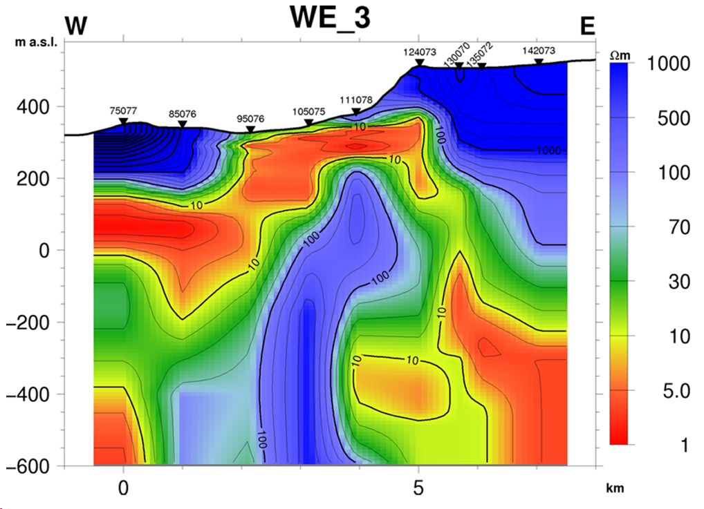
Image 1: Resistivity Profile based on TEM data, Theistareykir Geothermal Field, Iceland: To the east and west there is a high-resistivity layer (>100 Ωm) reflecting an unaltered rock formation. Below the high-resistivity layer, a low-resistivity layer (<100 Ωm) is found that correlates with a known alteration zone. (From Kahwa, E., 2012)
MT is a passive method that relies on the earth’s natural electromagnetic field. It combines measurements of the earth’s electrical and magnetic fields and is able to map depths > 500 m. This ability makes MT a very important tool as many geothermal systems for electricity generation lie between 1500 – 4500 m. MT can be applied during and post-production to track injected fluids and to follow the effect of production and fluid distribution in the reservoir. The figure below shows MT distribution at the Olkaria Domes, Kenya.
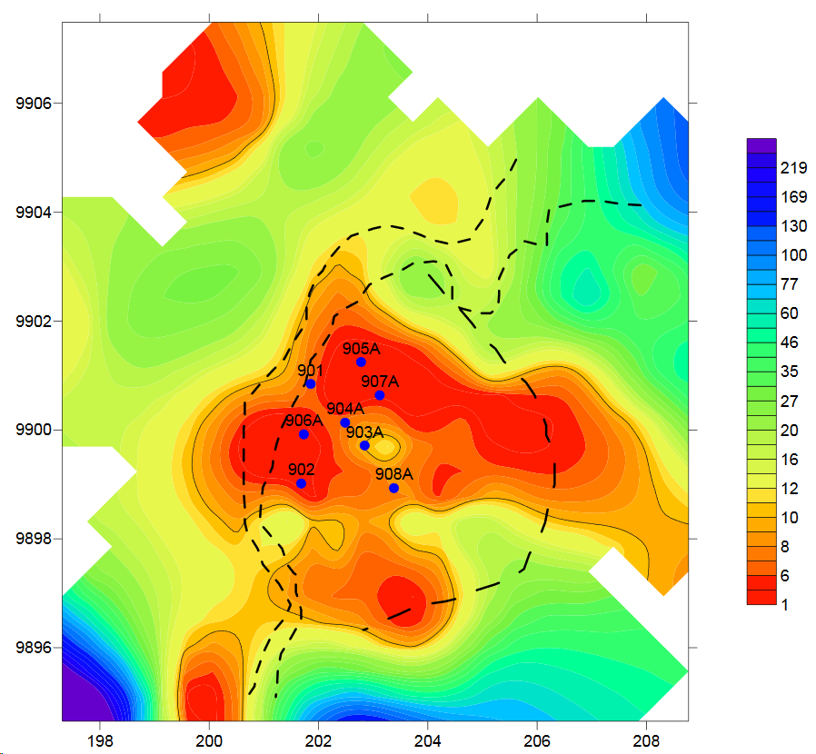
Image 2: Magnetotellurics (MT) distribution map of Olkaria Domes, Kenya (from Mariita, N.O., 2011)
Thermal methods involve direct temperature/heat measurements. Mapping temperature at the surface (less than 1 m) is simple and is based on soil temperature and Airborne Infrared surveys. For example, airborne thermal imagery was collected using drones during geophysical surveys in northern British Columbia, Canada earlier this year. To map vertical variations in temperature, deeper soil temperature surveys and gradient wells (20-300 m) are used. This temperature data is best used to assess local geothermal areas. In order to examine regional/global temperature variations, we use heat flow maps. Heat flow is calculated from temperature gradients and thermal conductivity. A great example of the heat flow map for the United States (Lower 48) seen below.
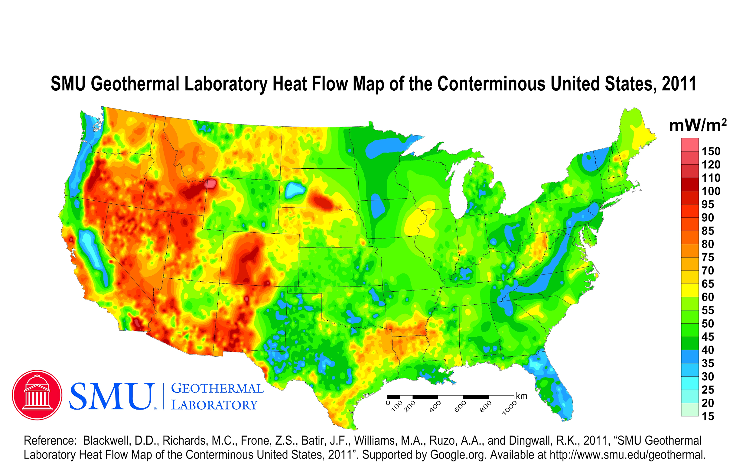
Image 3: SMU Geothermal Laboratory Heat Flow Map of the Conterminous United States, 2011
Indirect geophysical methods are extremely useful for mapping of geothermal systems with electrical methods being the most important. It has been used in all major geothermal fields and in those in early stages of exploration. For further details on these geophysical methods, we recommend taking a look at this report by Hersir, G.P., and Björnsson, A., (1991).
This concludes part 1 of our 2 part #GeothermalFactsandStats blog series Geophysical Mapping in geothermal energy. Check back this time next week to pick up where we left off on geophysical mapping, focusing on indirect methods.
Guest Blogger: Jason Fisher
Sources:
Blackwell, David, M. Richards, Z. Frone, J. Batir, A. Ruzo, R. Dingwall, and M. Williams 2011, SMU Geothermal Laboratory Heat Flow Map of the Conterminous US, 2011, supported by google.org, http://www.smu.edu/geothermal, Accessed on March 31, 2019.
Georgsson, L.S., 2009, Geophysical Methods used in Geothermal Exploration, Presented at Short Course IV on Exploration for Geothermal Resources, organized by UNU-GTP, KenGen and GDC, at Lake Naivasha, Kenya, November 1-22, 2009, 16 pp, https://geothermalcommunities.eu/assets/elearning/2.15.UNU-GTP-SC-10-0401.pdf Accesed on March 27, 2019
Global UAV Flies First Drone-Based Geothermal Energy Survey, January 24, 2019, https://globaluavtech.com/news-media/news/2019/global-uav-flies-first-drone-based-geothermal-energy-survey/ Accesed on March 27, 2019
Hersir, G.P., and Björnsson, A., 1991, Geophysical exploration for geothermal resources, principles and applications, UNU-GTP, Iceland, report 15, 94 pp, https://orkustofnun.is/gogn/unu-gtp-report/UNU-GTP-1991-15.pdf Accessed March 30, 2019.
International Geothermal Association Service GmbH, 2014, Best Practices for Geothermal Exploration, c/o Bochum University of applied Sciences (Hochschule Bochum), Lennershofstr, 140, D-44801, Germany, 195 pp.
Kahwa,E., 2012, Geophysical exploration of high-temperature geothermal areas using resistivity methods – case study: Theistareykir area, NE-Iceland, Geothermal Training Programme Reports Number 14, 2012, 29 pp, https://orkustofnun.is/gogn/unu-gtp-report/UNU-GTP-2012-14-1.pdf Accessed on March 30, 2019
Mariita, N.O., 2011 Application of geophysical methods to geothermal energy exploration in Kenya, Presented at Short Course VI on Exploration for Geothermal Resources, organized by UNU-GTP, GDC and KenGen, at Lake Bogoria and Lake Naivasha, Kenya, Oct. 27 – Nov. 18, 2011, 9 pp, https://orkustofnun.is/gogn/unu-gtp-sc/UNU-GTP-SC-13-0105A.pdf Accesed on March 27, 2019
Richter, B., Steingrímsson, B., Ólafsson, M., and Karlsdóttir, R., Geothermal Surface Exploration in Iceland, Proceedings World Geothermal Congress 2010 Bali, Indonesia, 25-29 April 2010, 6 pp, https://www.geothermal-energy.org/pdf/IGAstandard/WGC/2010/1135.pdf Accessed on March 29, 2019
Shah et al, 2015, Overview of geothermal surface exploration methods, Vol-1 Issue-4 2015 IJARIIE-ISSN(O)-2395-4396, 10 pp http://ijariie.com/AdminUploadPdf/Overview_of_Geothermal_Surface_Exploration_Methods_ijariie1277_volume_1_14_page_55_64.pdf Accessed on March 29, 2019
Think Geoenergy 2019, Drilling Finland’s deepest well on record – the geothermal well at Otaniemi http://www.thinkgeoenergy.com/drilling-finlands-deepest-well-on-record-the-geothermal-well-at-otaniemi/ Accessed on March 31, 2019.