

Geothermal Facts and Stats #7
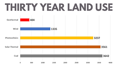
The 7th installment of our #GeothermalFactsandStats campaign looks at energy-related land use. This point was originally published by the Geothermal Energy Association in 2008. Side note: The Geothermal Energy Association recently unified with the Geothermal Resources Council. I would imagine the advancements in technology have adjusted these numbers slightly. However, the estimated square meters of land use should still stand true today.
Essentially, the GEA published a “Geothermal Basics” article on their website highlighting land use statistics over a 30-year span from the Bureau of Land Management, (BLM). Here is an excerpt from this post:
Geothermal development activities result in lower long-term land disturbance than other technologies. In its 2008 Programmatic Environmental Impact Statement, the BLM estimated that the total surface disturbance for a geothermal power plant ranges from 53 to 367 acres. This covers all activities such as exploration, drilling, and construction, and reflects variability in the actual area of land disturbance based on site conditions and the size and type of geothermal plant. Much of this land is reclaimed after the exploration, drilling, and construction phases of development, so the long-term land use is much lower.

It is important to note for comparison purposes that this finding breaks out land use throughout development, assuming plant sizes of a range between 30 MW and 50 MW.
Stay tuned for more #GeothermalFactsandStats on this blog and our social platforms Twitter, LinkedIn, Facebook and Instagram.